Climate Matters•September 9, 2020
Worsening Western Wildfires
KEY CONCEPTS
Human-caused climate change is adding to the heaping tinderbox of wildfire risk. Warmer temperatures and worsening drought make for more dry vegetation, elevating the risk of a fire igniting and the fire spreading.
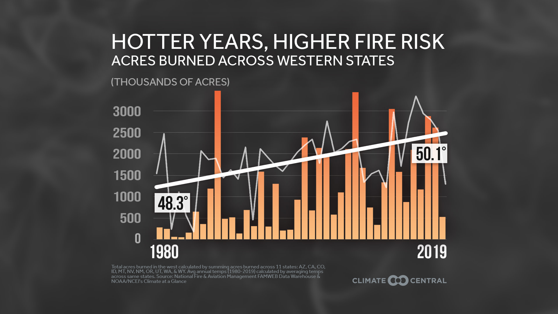
The West has warmed nearly two degrees on average since the 1980s, while the number of acres burned by wildfires has exploded. In California, over 12 million acres have burned between 1980 and 2019, which is more than any other western state included in our analysis.
The increasing size of wildfires coupled with more people and homes at risk also puts a strain on emergency services. Even hundreds of miles from a blaze, smoke waves from wildfires can endanger public health 一 particularly among at-risk populations, including people with chronic health conditions and outdoor laborers like farm workers.

For much of the western U.S., record summer heat is expected to bleed into the fall, as California keeps working to contain some of the largest and most destructive wildfires the state has ever recorded. After an abnormally dry winter and sustained heat since then, land managers were already anticipating an active fire season. However, the size and intensity of this year’s fires has prompted discussion of a new “megafire era,” as climate change continues to add to the already heaping tinderbox of wildfire risk.
The West has warmed nearly two degrees on average since the 1980s, while the number of acres burned by wildfires has exploded. In California, over 12 million acres have burned between 1980 and 2019, which is more than any other western state included in our analysis. This year’s fire season in California has already surpassed its all-time record of acres burned, which was set in 2018. Higher temperatures mean more evaporation, which worsens drought and dries out vegetation, elevating the risk of a fire igniting and spreading. One study found that climate change has resulted in a doubling of forest fire acres between 1984 and 2015.
Human development has increasingly encroached on forested areas, suppressing natural fire regimes and exposing more communities to the risk of wildfires. The increasing size of wildfires coupled with more people and homes at risk also puts a strain on emergency services. Even hundreds of miles from a blaze, smoke waves from wildfires can endanger public health 一 particularly among at-risk populations, including people with chronic health conditions and outdoor laborers like farm workers.
For more reporting resources, click here to catch up on our recent ‘Smoke, Health and Fire’ workshop.
POTENTIAL LOCAL STORY ANGLES
Are wildfires affecting air quality in your area?AirNow, a partnership of multiple government agencies, has a number of publications on wildfire smoke and air quality, and a wildfire and smoke tracking map. California Air Resources Board (CARB) maintains a series of interviews with experts on wildfire smoke and air quality, that are available for attribution, as well as air quality data. Purple Air also maps air quality indexes across the country.
Is my area at risk of wildfires? You can stay updated about risk of fire with the North American Seasonal Fire Assessment and Outlook, produced by the National Interagency Fire Center (NIFC) in Boise, Idaho at the beginning of each month. You can also search your locality on the Wildfire Risk to Communities website.
How are local emergency managers responding to wildfires? You can find out about your state’s plans and measures taken against wildfires by contacting your local Emergency Management Agencies. Also, take a look at the NIFC’s plans for nine geographic regions to help guide effective wildfire responses during the COVID pandemic.
EXPERTS TO INTERVIEW
Local Experts
The SciLine service, 500 Women Scientists or the press offices of local universities may be able to connect you with local scientists who have expertise on air quality in your area, as well as a fact sheet and experts ready to talk about wildfires. Climate Signals has materials on climate change and wildfires and the American Association of State Climatologists is a professional scientific organization composed of all 50 state climatologists.
National Experts
Erin Landguth, Associate Professor, School of Public and Community Health Sciences, University of Montana, Missoula. Research interests: computational ecology and the relationships between biological processes, environment, and climate with population patterns. erin.landguth@mso.umt.edu
John Abatzoglou, Associate Professor, University of California, Merced. Research interests: climate variability, climate and weather and their collective influence on drought, wildfire and agriculture. jabatzoglou@ucmerced.edu
METHODOLOGY
The total number of acres burned from 1980-2019 was obtained from the National Fire and Aviation Management’s FAMWEB Data Warehouse for each western state, including: Arizona, California, Colorado, Idaho, Montana, Nevada, New Mexico, Oregon, Utah, Washington, and Wyoming. The total western acres burned was calculated by summing the individual state acres. Some fires may not be included in the database. Average annual temperatures (1980-2019) were calculated by averaging temperature data obtained from NOAA/NCEI’s Climate at a Glance across the same western states.