Climate Matters•March 30, 2022
Water in the West
KEY CONCEPTS
Exceptional drought and our warming climate are putting Western water supplies at risk.
More than 44 million people across the western U.S. are experiencing drought as we approach this year’s April 1 snowpack surveys—an annual indicator for each year’s water supply.
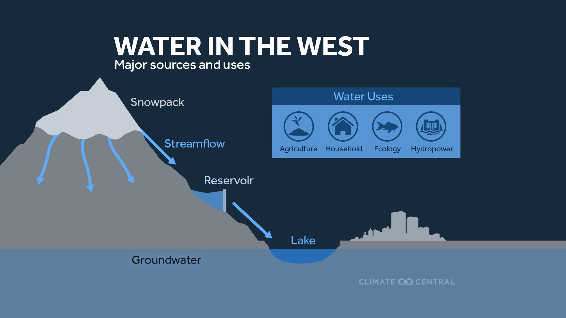
Western mountain ranges act as natural water towers—storing snowpack each winter that later melts to recharge reservoirs and meet the majority of the region’s water demands.
But warmer, dryer winters mean smaller snow reserves that melt earlier and need to stretch longer into the warm seasons when the region’s water demands peak.
The wilted west
The western U.S. has fallen into an extreme dry spell. California, Nevada, Oregon, Washington, and Idaho have had an exceptionally dry wet season, and more than 44 million people are experiencing drought across these five states.
The country's two largest reservoirs, Lake Mead and Lake Powell, are both at record-low levels since they were first constructed 86 and 56 years ago, respectively. And drought conditions are forecast to continue for the vast majority of the western U.S. at least through June.
Drought and dry spells are common in the west, but recent years have been unprecedented. The ongoing southwestern megadrought (since 2000) is the most severe of the past 1,200 years, and a recent study suggests that the drought would be 42% less intense without human-caused climate change.
Exceptional drought and our warming climate put water in the west—and the people, ecosystems, and food supplies that depend on them—at risk.
Western water demands
The western U.S. is a large region with diverse water demands including water supplies for rural communities, growing cities, tribal nations, and critical ecosystems—as well as agricultural, industrial, and hydropower uses.
Irrigation is the largest of all western water demands. The 17 western states account for 81% of the country’s irrigation water use. California has the highest irrigation water demands of any state and supplies much of the country’s fruit, nuts, and produce.
When there isn't enough water to meet these demands, it can have costly consequences. According to preliminary estimates from researchers at University of California Merced, drought in 2021 cost California's agriculture sector an estimated $1.1 billion and nearly 8,750 jobs.
And despite water supply risks, western states have some of the country’s highest rates of domestic water use per person.
How does the west meet its water demands?
Snow makes up more than 50 percent of the water supply across the entire western U.S., and more than 70% in mountain regions.
Western mountain ranges act as natural water towers. Snowpack accumulates at high elevations during cooler months and melts during warmer months—flowing downhill to recharge reservoirs, streams, and groundwater aquifers that support the region’s people, ecosystems, and industries.
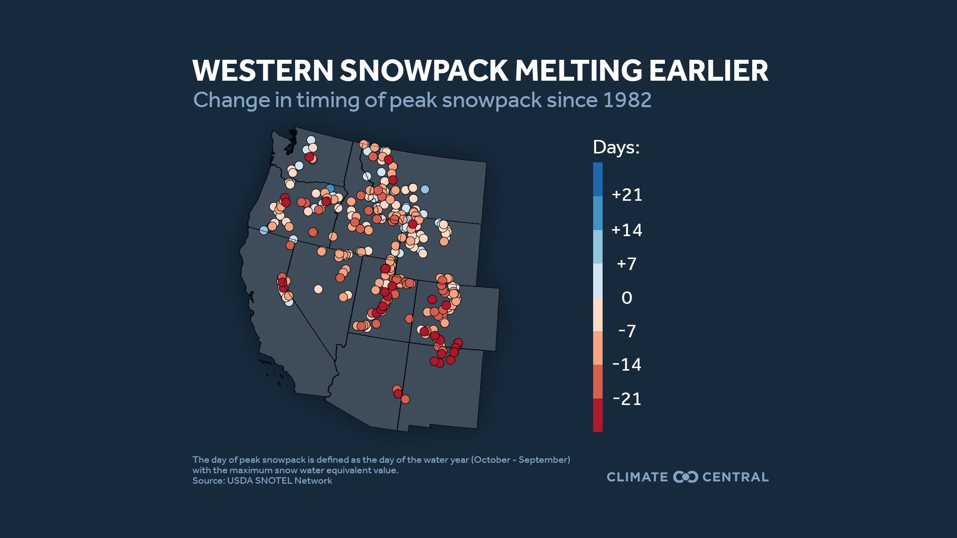
But since the 1950s, the west has experienced declining snowpack and a shift toward less precipitation falling as snow. Warmer winters also cause earlier snowmelt, which makes it harder for each year’s snowpack to last into the warmer seasons when water demands peak.
These trends could continue, with an additional 25% decline in snow-derived freshwater expected by 2050—putting pressure on another important regional water source: groundwater.
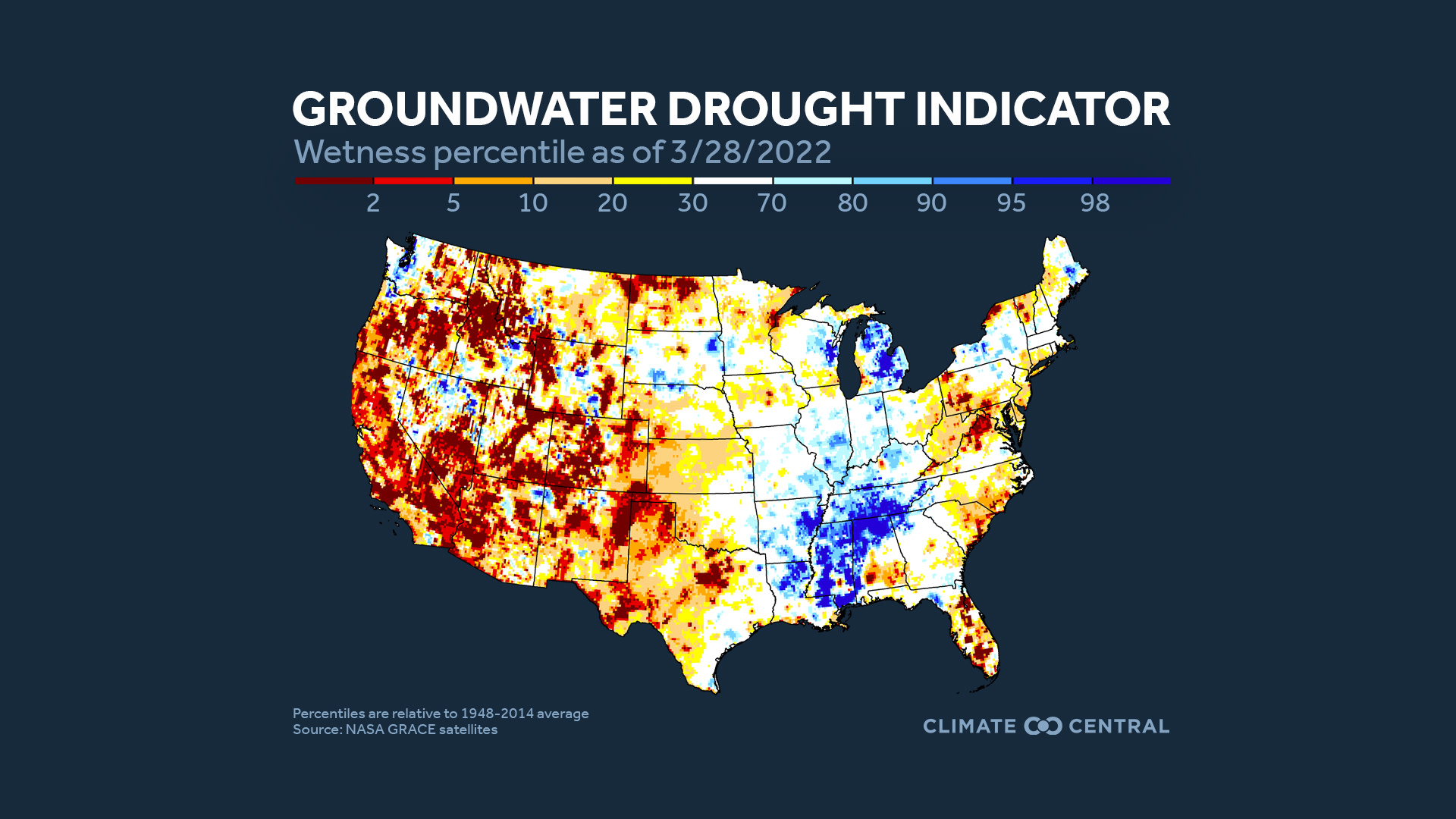
Groundwater is underground water held in the cracks and pores of rocks and soil. Groundwater aquifers, which are recharged by rainfall and runoff, provide irrigation for agriculture and drinking water for millions in the west.
But satellite data show groundwater depletion throughout the west, especially in agricultural areas such as California’s Central Valley where up to 40% of irrigation water comes from groundwater aquifers, and up to one‐in‐five groundwater wells now run dry during peak drought.
Climate change plays a role in western water stress, which is likely to continue. Human-caused climate change and its impact on snow was responsible for 30-50% of declining streamflow in the Colorado River Basin in recent decades. And consecutive years with snow drought are projected to become more frequent in the coming decades, especially under a high-emissions scenario.
For water in the west, timing is everything—and April 1 is key.
There’s a mismatch between when snow accumulates and when snow-derived water is needed to meet peak agricultural, ecological and public demands in the west.
Water managers track these seasonal cycles using the “water year”, a 12-month period starting every October 1 as snow begins to accumulate. Snow surveys on April 1 (halfway through the water year) are an important indicator of the water supply available each year to meet peak warm season demand.
But snow-derived freshwater available on April 1 in the west has declined by 15-30% since 1955. This is partly due to shrinking April snowpack. But a widespread shift toward earlier peak snowpack also means that the April 1 snow reserve needs to stretch longer into the peak demand months.
The region’s water infrastructure, which includes dams and reservoirs, has supplied its water for over a century. But it was designed to manage and store reliable spring and summer melt of snowpack. As the amount of mountain snowpack decreases and the timing of snowmelt shifts earlier, water management strategies in the west are adapting to low-snow conditions.
Climate-resilient water supplies
It is becoming increasingly difficult to maintain a stable water supply in the West due to both climate change and increasing water demands. Existing approaches to reduce water stress on residents, ecosystems, and industries include:
Investing in water infrastructure. Repairing aging dams, canals, wastewater facilities, and leaky pipes can conserve and enhance the water supply.
Encouraging water reuse. Recycling wastewater and stormwater for non-drinking uses, such as irrigating crops and flushing toilets is an effective way to conserve water.
Implementing water-efficient agriculture. Water-efficient practices like drip irrigation, drought-resistant crops, and cover crops can reduce water waste and optimize soil moisture.
Saving water at home. Water-efficient appliances and practices in home kitchens, laundry rooms and bathrooms, as well as low-water landscaping, can also reduce water demand.
POTENTIAL LOCAL STORY ANGLES
How can we mitigate the risk of drought?
Check out this list of each state’s drought management plans maintained by the NDMC. You can browse the Solutions Story Tracker by the Solutions Journalism Network for inspiration. Project Drawdown and EPA’s WaterSense also provide information on water conservation and efficiency strategies.
How can I conserve water at home?
Americans use, on average, about 82 gallons of water a day and waste over 30 gallons. That’s a lot of water going down the drain! You can track how much water your household uses with the Water Footprint calculator. After answering a series of questions, the site provides you with tips on saving water and money. Some examples include:
Turn off the bathroom faucet when you brush your teeth
Use low-flow facets/showerheads and energy-efficient appliances
Plant native plant species in your yard
Fix leaky water faucets and pipes
LOCAL EXPERTS
The SciLine service, 500 Women Scientists or the press offices of local universities may be able to connect you with local scientists who have expertise on water supply and climate change. The American Association of State Climatologists is a professional scientific organization composed of all state climatologists.
NATIONAL EXPERTS
Erica Woodburn, Ph.D.
Research Scientist
Energy Geosciences Division
Lawrence Berkeley National Laboratory
Lead Author, A low-to-no snow future and its impacts on water resources in the western United States
Contact: erwoodburn@lbl.govLiz Payton, M.S.
Water Resources Specialist
Western Water Assessment
Cooperative Institute for Research in Environmental Science (CIRES)
University of Colorado, Boulder
Contact: elizabeth.payton@colorado.eduSamuel Sandoval, Ph.D.
Associate Professor
Cooperative Extension Specialist in Water Management
University of California, Davis
Contact: samsandoval@ucdavis.edu
*interviews available in English and SpanishDylan Hedden-Nicely, J.D.
Associate Professor
Director, Native American Law Program
Director, Natural Resources & Environmental Law Program
University of Idaho, College of Law
Contact: dhedden@uidaho.edu
METHODOLOGY
The date of peak snowpack was analyzed at 330 SNOTEL sites across the western United States from 1982-2021 (water year, October through September) using daily snow water equivalent data from the U.S. Department of Agriculture. The groundwater percentile map was obtained from NASA’s GRACE website.