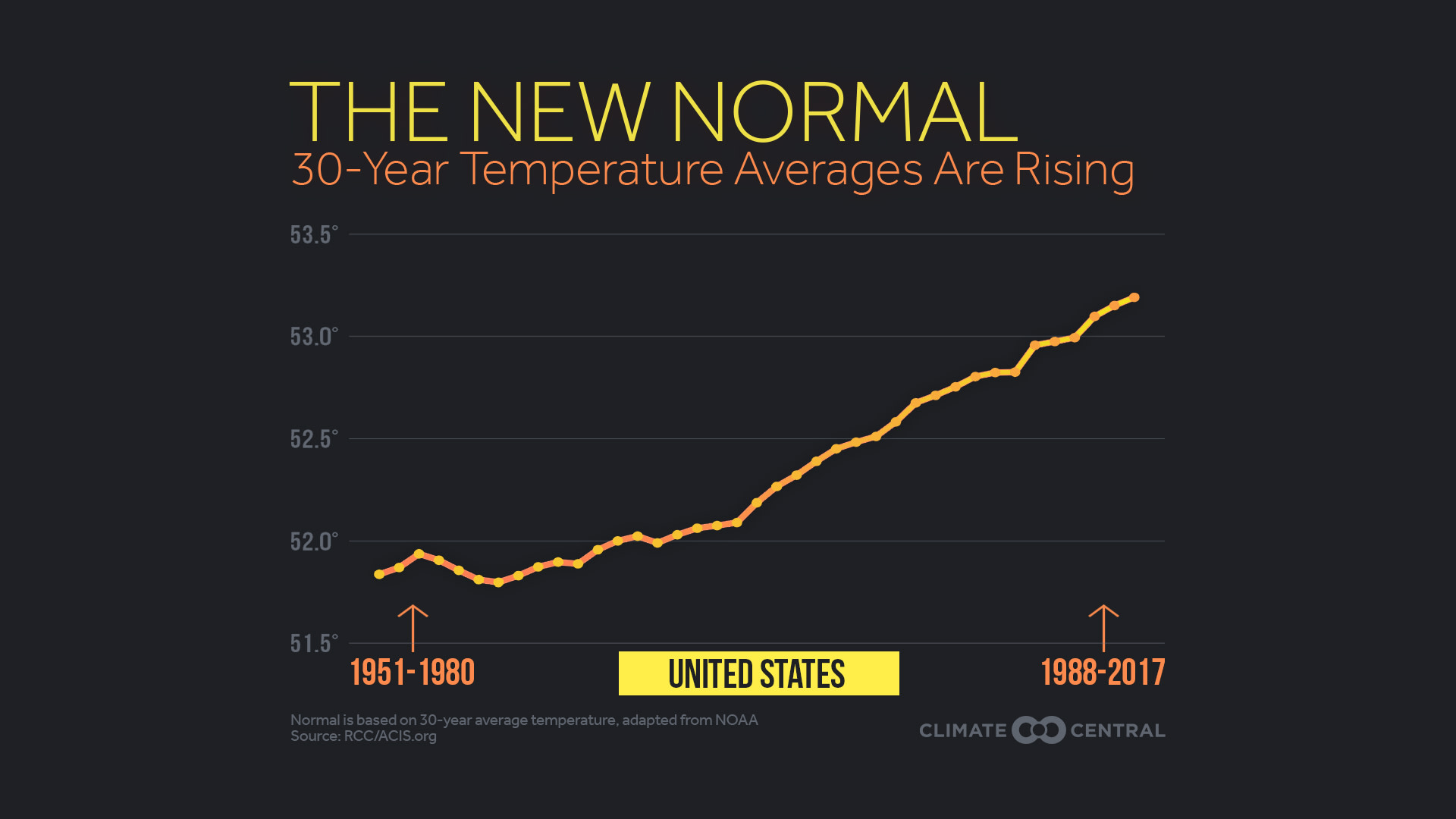
Normal temperatures, generally defined to be the 30-year average at a location, are trending up across most of the U.S. Since 1980, the average continental U.S. temperature has risen 1.4°F. In our analysis of normal temperatures in 244 cities across the country, 94 percent have risen, providing more evidence of the long-term warming trend on our planet.
The warming signals a new normal not just for our temperatures, but for the composition of our oceans and our atmosphere. In a recurring theme, Arctic sea ice is again at an exceptionally low level for this time of the year, with the lowest April level in the satellite era in the Bering Sea, just west of Alaska. There was enough open water over the winter to allow heavy surf to flood coastal homes in Alaska, where an ice-covered sea is normally in place to protect the shore.
The warming is fueled by the ongoing increase of carbon dioxide in the atmosphere — primarily from the burning of fossil fuels. In April, CO2 passed another milestone when the monthly average concentration reached 410 parts per million for the first time in the pristine air at the top of Mauna Loa in Hawaii, where scientists conduct measurements. Concentration of atmospheric carbon dioxide has now climbed more than 30 percent in the 60 years of observations there.
Even with the chilly spring in parts of the U.S., the first four months of 2018 have been cumulatively warmer than normal. Incessant heat in the Southwest this year has dominated the cool spring east of the Rockies. Globally, Germany had its warmest April on record, and it was nearly the warmest April on record for the rest of Europe, Australia, and southern South America. When the NOAA global temperature analysis is released Thursday, it will likely indicate that April was the 400th consecutive month warmer the 20th-century average.
Warmer Normals, More Heat Extremes
While the rise in average temperature may seem small, it results in a large increase in the number of extremely hot days and a dramatic drop in the number of extremely cold days. This has been seen in the daily temperature records in the U.S., in which daily record highs have outnumbered daily record lows in 26 of the last 30 years, with that ratio as high as 7-to-1 in 2012.
Methodology: Official normal temperatures, published by NOAA every 10 years, reflect the most recent 30-year averages. The current normals come from the period between 1981 and 2010. Our analysis calculated a running 30-year average ending each year from 1980 to 2017. For example, the normal temperature for 1980 in this analysis was based on the average temperature from 1951-1980, and the 2017 normal is the average from 1988-2017. Former Weather Channel meteorologist Guy Walton maintains a comprehensive U.S. temperature records database, analyzing monthly, annual, and decadal records trends. Please contact us if you would like to see the full data set.
