Climate Matters•October 8, 2014
Sea Level Rise is Increasing Coastal Flood Risk
It’s King Tide time again in Miami Beach, and that means trouble. A King Tide is by definition the highest tide of the year. It’s caused when the sun and moon (whose gravity causes tides in the first place) line up with the Earth, reinforcing each other’s effects. The timing varies based on local geography, but Miami is in the crosshairs for this Thursday, Oct. 9. At a significant expense, officials have scrambled to install pumps to prepare for the rising water.
A King Tide would be a problem in any case, but rising seas caused, in part, by climate change have made it progressively worse over the past few decades, especially in Miami Beach. That extra foot delivered by a King Tide comes on top of an ocean that’s already higher, making the inevitable flooding that comes with a King Tide just that much more severe. And it’s not just tides that have gotten more destructive with rising seas; so have storm surges. For example, the Superstorm Sandy’s surge in 2012 caused more damage than it would have if the same storm hit a century ago.
As climate change continues to drive sea level even higher, the extra punch that it gives to tides and storm surges will just get stronger. That extra strength will vary from one part of the country to another, though, because sea level is rising at different rates in different places.
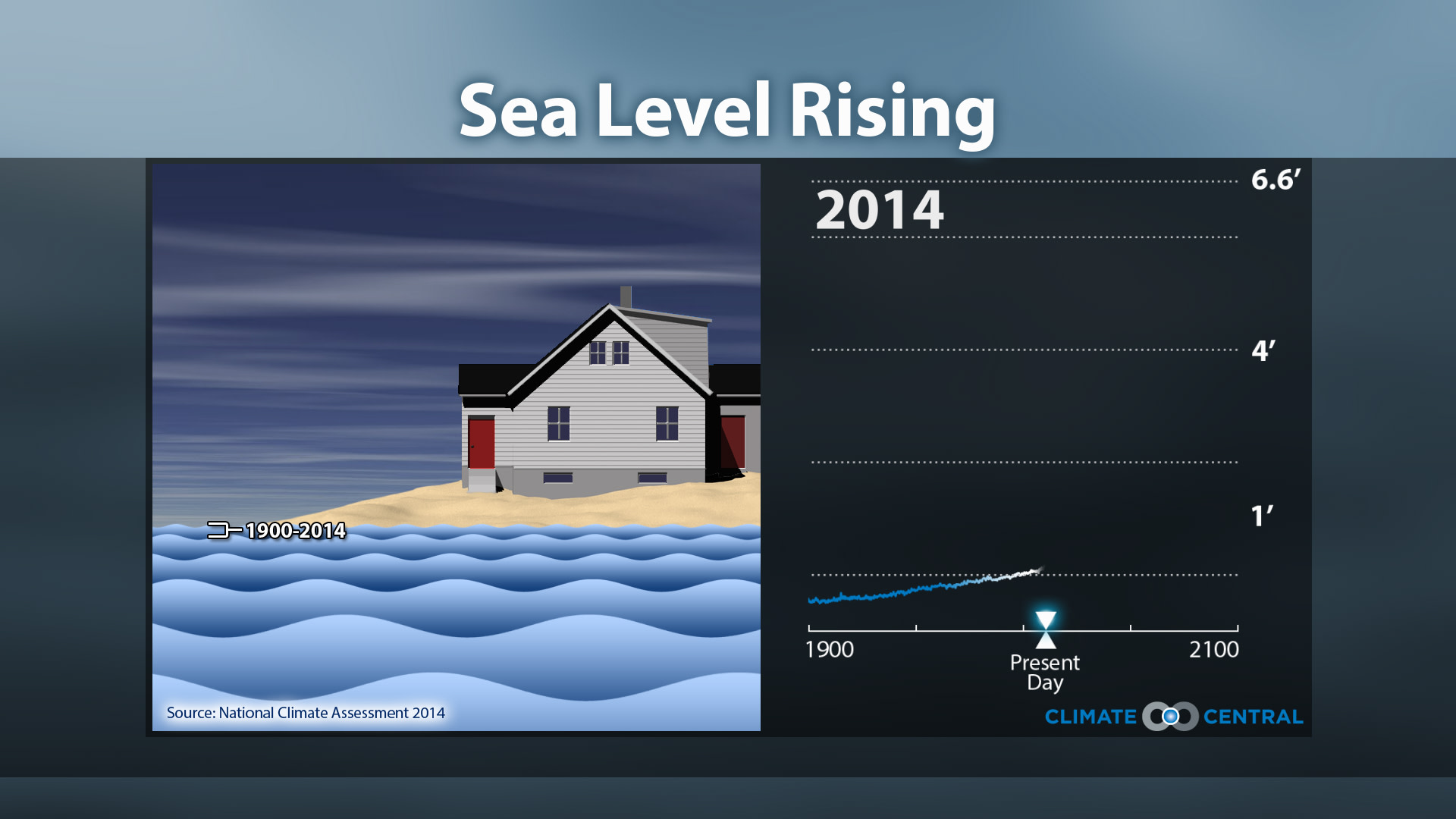
In the Northeast, for example, it’s rising faster than waters elsewhere in the country for a couple of reasons. The main factor is that the land itself is gradually sinking in the aftermath of the last Ice Age. Along the Gulf Coast, the land is deflating thanks to the withdrawal of underground oil and gas supplies, plus the Mississippi delta is sinking as soft sediment compresses. All of these areas have seen more than the global average of about 8 inches of sea level rise since 1900.
Meanwhile, the West coast has registered less of a rise, thanks to shifting currents and winds over the past few decades that have been pushing water away from the shoreline of the East Pacific (our west coast) and toward the West Pacific (Asia). This pendulum is expected to swing back within the next couple of decades. And tectonics are causing most of the California coast to slowly sink, while parts of the Oregon and Washington coasts are slowly rising.
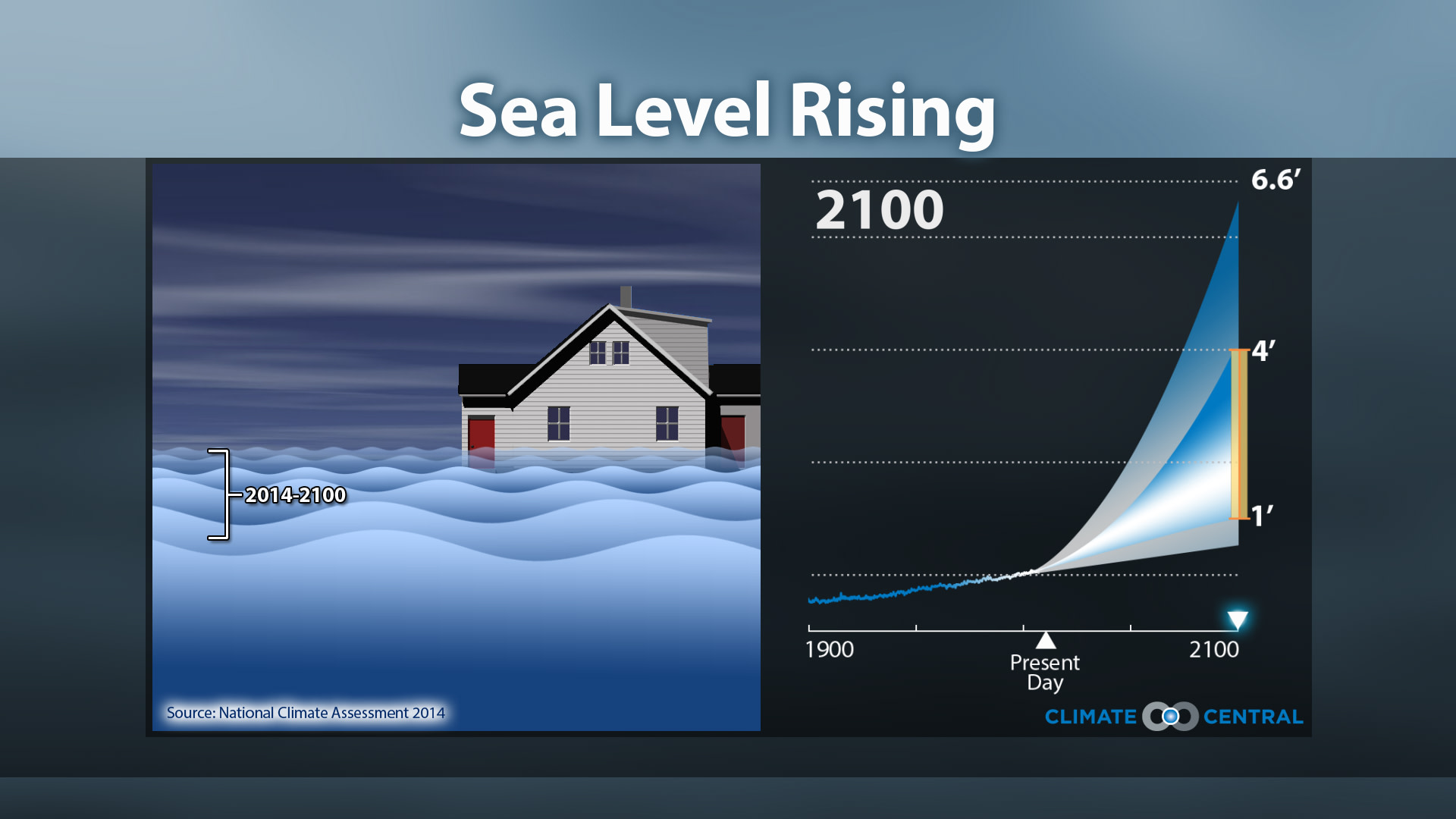
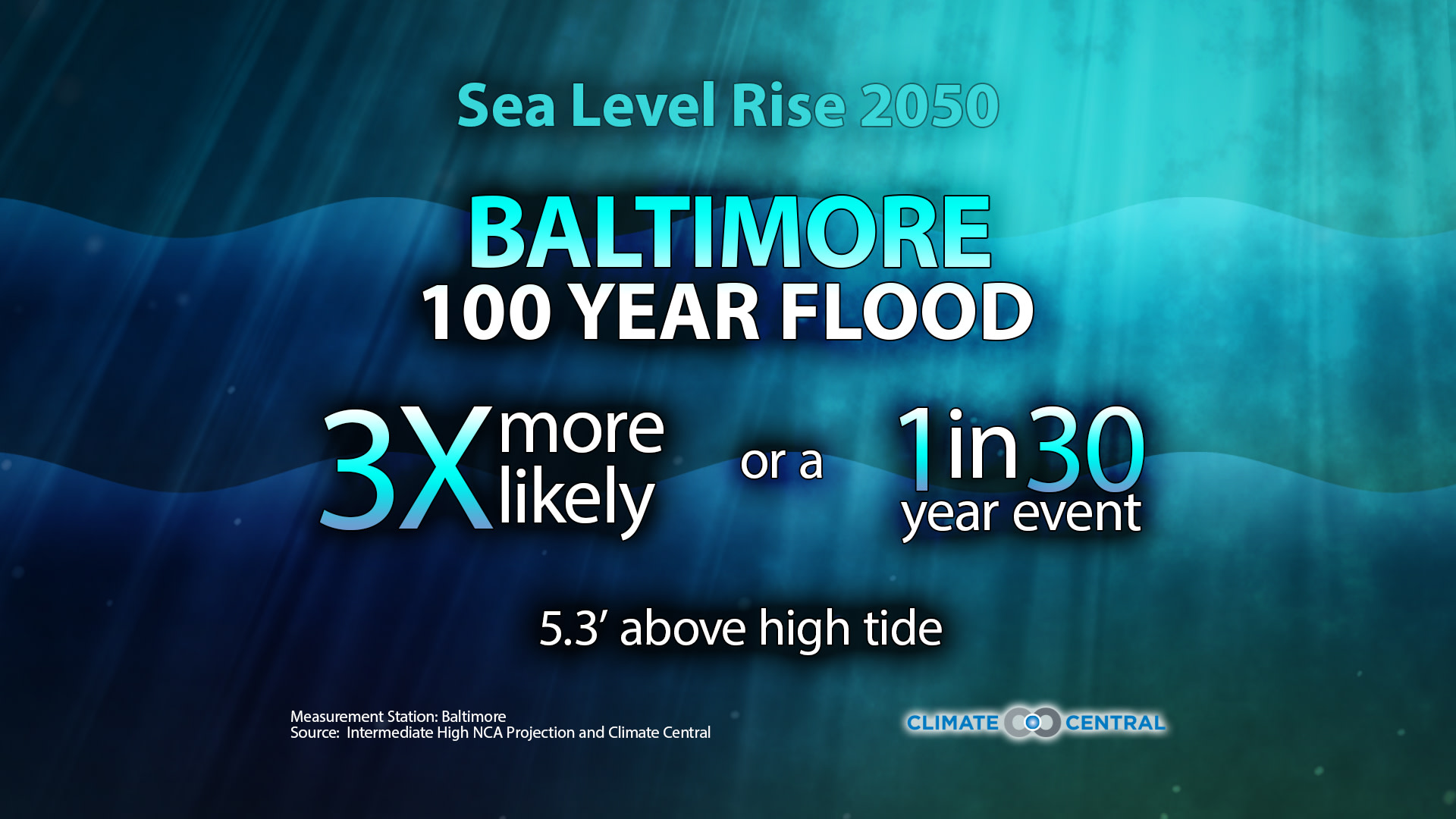
How much of an impact local sea level rise has on coastal flooding also depends on local geographic factors — how sharply the land rises from the sea, whether marshes and sand dunes are there to blunt the force of waves and storm surges, and more. One way to discuss future sea level rise and coastal flood risk is through the lens of 100-year floods — that is floods so severe they happen just once every century, on average. In other words, a 1 percent chance of the flood happening in any given year. How much more likely will such a flood be in the year 2050 because of sea level rise? What scientists are finding is that if you look at a medium-high projections for heat-trapping CO2 emissions and the sensitivity of sea level to warming (neither the worst-case nor the best-case scenario), today’s 100-year coastal floods will be happening a lot more often in the future.
NOTE: We calculate the 100-year flood level based on an (extreme-value-statistics) analysis of at least 30 years of hourly water level data from a NOAA tide gauge. We then adjust this risk for the future based on projected sea level rise. Also, we factor in only sea level change, and not possible changes in storm strength or frequency, into this analysis.